Friday, October 1, 2010
Wednesday, July 7, 2010
Sepia Saturday #30
The Lighthouse Inn
In 1850, the federal government appropriated $4000 to build a lighthouse near the breakwater at the mouth of the Bass River on Cape Cod Massachusetts. Although an officer of the Marine Revenue reported that a light was unnecessary, the plans were carried through because the captains of the ships had been putting in 25 cents per month of their own money to buy kerosene for a lantern that was placed on Wrinkle Point in West Dennis. In 1854, construction began on the light and the keeper’s home. Oxen were used to drag the materials over the salt marshes and dunes.
The light was lit on May 1, 1855, and continued in service until 1880, when the Lighthouse Service decided the Bass River Light was no longer necessary since a new light had been built at Stage Harbor in Chatham. One year later, the government changed its mind and decided to relight the Bass River Light. The light continued to serve seafarers until 1914, when it was decommissioned after the Cape Cod Canal opened.
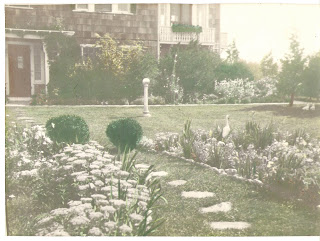
After being sold at auction, the Lighthouse property was purchased by Harry Noyes of the Noyes Buick Company in Boston. Noyes enlarged the Main House, built several buildings, and landscaped the grounds. After his death in 1933, the property was on the market for five years until Everett Stone - - at the urging of his wife Gladys - - purchased the Lighthouse property. Their son Robert helped by putting in $1000 inherited from his grandparents.
Everett was a developer from Auburn, Massachusetts. He planned to develop the land and sell it. But the papers on the Lighthouse were passed too late in June to begin any construction, so Gladys Stone decided to take in overnight guests to help pay the mortgage. So many of the 1938 guests asked to return, the Stones changed their mind about developing the land and thus began Lighthouse Inn.
Since there were very few restaurants nearby, in 1939, Gladys and Everett decided their son Bob would run the dining room for the Lighthouse. Bob hired three waitresses from Wheaton College, including Mary Packard. Bob and Mary were married in 1942, starting the tradition of family operation of the Inn.
After the death of Everett Stone in 1947, Bob, Mary and Gladys continued to run the Lighthouse over the next three decades. Bob and Mary have continued to run the Inn while raising five children at the Lighthouse - Betty Anne, Deborah, Barbara, Jonathan and Gregory, all of whom have worked at the Inn at one time or another in various capacities. Gregory and his wife, Patricia, who started at the Inn in the late ‘70's as the Children's Director, now manage the day-to-day operations of the Inn.
After being dark for 75 years, the light was relit as the only privately owned, privately maintained working lighthouse in the country. The light, which is a one-second flash every six seconds is now recognized by the Coast Guard as the West Dennis Light. The light was relit on August 7, 1989, in conjunction with the 200th anniversary of the U.S. Lighthouse Service, now the U.S. Coast Guard.
The early days of automobiles circa 1908
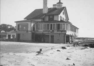
The beginning of Lighthouse Inn 1938
The foundation was all that remained.
June, 1945 - A new dining room and kitchen were constructed on
a steel frame with walls designed to breakaway in the event of hurricane.
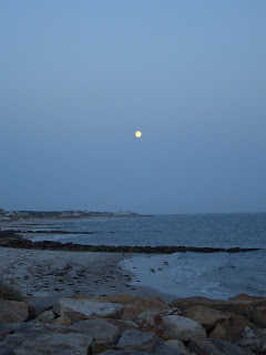
And here it is today, my favorite place on Cape Cod... these are my own photos, and I'm heading out next week for a fun in the sun vacation!
Black and white photographs, postcards and history are from the Lighthouse Inn website.
Color photographs ©2010 by Janice Stiles-Boults; property of Jan Boults Photography
Friday, June 25, 2010
Sepia Saturday #29 - Hastings Family
Last week I posted a few amusing pictures of the Harry Hastings family enjoying an afternoon at their beach house. This week I dug deep into the photo archives to come up with more on the Hastings and the beginning of that family.
Here we have a Souvenir List from a European cruise in 1894, upon the Cunard Steamer "Umbria", where my maternal great grandparents met for the first time. Listed member, Miss Margaret Watrous of Wellesboro Pennsylvania is my great grandmother, and Mr. H. L. Hastings of Worcester, Massachusetts is my great grandfather.
The young couple -
Harry Leander Hastings
4-19-1875/10-26-1946
Margaret Isabelle (Smith) Watrous Hastings
12-8-1872/3-15-1950
This photo shows Harry & Margaret leaving on their honeymoon on October 20, 1898.
 Harry & Margaret made their home at 23 Westland Street, Worcester, Massachusetts, the same city in which Harry ran the family business, "The L. A. Hastings Co.-Fine Harness & Leather Goods". Photo circa: early 1900's.
Harry & Margaret had five children:
Frances Watrous, Sept. 21, 1899-May 25, 1994;
Twins, Elizabeth Lucy & Gerald Leander, August 20, 1903
Gerald died Feb. 18, 1947 - Elizabeth died Oct. 6, 1965
Martha Watrous, March 4, 1905-May 20, 1980
Harry Leander Hastings, Jr., Jan. 12, 1912-Dec. 24, 1938
Shown here are three generations of Hastings men, circa 1905:
Leander Augustus Hastings
Harry Leander Hastings
Gerald Leander Hastings
I love the caption written on this photo dated August 1905, "In the good old summertime". Showing the twins, Elizabeth & Gerald and eldest daughter Frances, with the nurse/nanny.
Circa apprx. 1908-1910
(The above photo was taken before Harry Jr. was born)
Friday, June 18, 2010
Sepia Saturday #28
Its Summertime!
Head to the Beach House!
My great grandparents owned a "Summer Cottage" at Sagamore Beach, Cape Cod, Massachusetts that they called "Two-Ways" as it had a fabulous view of the bay on one side, and lovely gardens on the other. Each year they would pack up and leave their city home in Worcester for fun in the sun! This family home was sold in the 1950's.
The photo below shows what might be a Sunday afternoon gathering, after a round of golf by the men -note that the attire doesn't quite seem beach appropriate- and they were entertaining a special guest. The approximate date is unknown, but through family birthdates I would guess this to be early 1930's.
They all seem very proper, although I notice that my great grandfather (on the far left), is glancing at Albert's shoes and smiling...
This one shows them all having a great laugh as Albert shows off his stylish shoes... high heels, seriously?
And then they all relax, after having a good chuckle...
L.to R.: Harry Leander Hastings, Martha Watrous Hastings, Bertha May Hastings, Margaret Isabelle Watrous Hastings, and family friend, Albert Hyde.
©2010 All photographs from the family archives, property of Janice Stiles-Boults.
Thursday, June 10, 2010
Sepia Saturday #27
Wedding Day
Remembering my parents
on their wedding day, June 12, 1943
Southfield, Massachusetts
My parents celebrated their 50th anniversary
June 12, 1993
In loving memory
Martha Louise Cook Stiles
8/28/1923-12/31/1994
Henry Raymond "Bud" Stiles
7/7/1920-5/11/2009
Friday, June 4, 2010
Sepia Saturday #26
The Great New England
Hurricane of 1938
From the family archives - photographs of the damage from the Great New England Hurricane of September 1938. Taken by my great grandfather, Howard Augustus Cook, in and around the Village of Southfield, Town of New Marlborough, Berkshire County, Massachusetts, New England!
From Wikipedia The Free Encyclopedia:
"The New England Hurricane of 1938 (or Great New England Hurricane or Long Island Express or simply The Great Hurricane of 1938) was the first major hurricane to strike New England since 1869. The storm formed near the coast of Africa in September of the 1938 Atlantic hurricane season, becoming a Category 5 hurricane on the Saffir-Simpson Hurricane Scale before making landfall as a Category 3 hurricane on Long Island on September 21. The hurricane was estimated to have killed between 682 and 800 people, damaged or destroyed over 57,000 homes, and caused property losses estimated at US$306 million ($4.7 billion in 2009 dollars). In 1951, damaged trees and buildings were still to be seen in the affected areas. To date it remains the most powerful, costliest and deadliest hurricane in New England history."
Massachusetts
Massachusetts
The eye of the storm followed the Connecticut River north into Massachusetts, where the winds and flooding killed 99 people. In Springfield, the river rose to 6 to 10 feet above flood stage, causing significant damage. Up to six inches of rain fell across western Massachusetts, which combined with over four inches that had fallen a few days earlier produced widespread flooding. Residents of Ware were stranded for days and relied on air-dropped food and medicine. After the flood receded, the town's Main Street was a chasm in which sewer pipes could be seen.
To the east, the surge left Falmouth and New Bedford under eight feet of water. Two-thirds of all the boats in New Bedford harbor sank. The Blue Hills Observatory registered sustained winds of 121 mph and a peak gust of 186 mph. The New Haven Railroad from New Haven to Providence was particularly hard hit, as countless bridges along the Shore Line were destroyed or flooded, severing rail connections to badly affected cities (such as Westerly) in the process.
Photographs ©2010 Property of Janice Stiles-Boults
Wednesday, May 5, 2010
Sepia Saturday #22 - "The Old Neighborhood Playhouse"
WWII Observation Tower (1940's). At the home of Palmer J. Cook, Southfield, MA. "Civil Defense efforts were largely manifested by the Defense Board and the Ground Observation Corps, a group of volunteers which, according to the New Marlborough Town Report of 1942, was headed by Palmer J. Cook, co-owner of Turner & Cook buggy whip factory in Southfield. The aircraft warning system used the structure pictured as an observation post... it was manned continuously 24 hours a day, and one of the few stations in this section of New England. It was discontinued in 1944.
The tower actually lived three lives. First as the WWII Observation Post; then it was moved just up the road where the fire department used the tower once again as an aircraft observation post... in the mid-1950's there was national concern that the US was vulnerable to atomic attack by the Soviet Union. The post's second life came to an end in 1957 when the DEW (Distant Early Warning) line system was completed and made operational.
The tower was acquired a few years later by a local resident and moved to their property on East Hill Road in Southfield. Its third and final life was a playhouse for the neighborhood children, and eventually razed in the 1980's." (Reported by David Lowman, NM 5 Village News, 2003).
A friend of mine commented on the photo: "How well I remember going up in the tower with your mom, and watching in awe as she would report what types of planes were flying over."
©2010 Photographs property of Janice Stiles-Boults
Subscribe to:
Comments (Atom)


